

Latest Weather Blog
Friday PM Forecast: hot and humid weekend, tropical depression three forms
The first half of the weekend will be slightly hotter and drier than the rest of the Storm Station 7-Day Forecast. Overall, very typical conditions are expected for July.
Tonight & Tomorrow: Any leftover showers will gradually wrap up through the evening. For WBRZ’s Fireworks on the Mississippi, expect clearing skies with temperatures falling into the low 80s. The rest of the night will feature mainly clear skies with a low in the mid 70s. It will be hard to find many spotty showers and thunderstorms on Saturday. A lot of sunshine is expected. Expect highs in the mid-90s. Enough humidity will be present to cause heat index values near 105 degrees at times. Stay hydrated and take breaks in the shade or air conditioning if enjoying time outside.
Up Next: Moisture will seep back into the region Sunday through Tuesday. This will help to ignite isolated to scattered showers and thunderstorms. Thanks to a pocket of disturbed air aloft, the showers and thunderstorms may not necessarily be limited to afternoons, but will be enhanced by daytime heating. The latter part of next week looks to feature a continuation of the average summer weather with highs in the 90s along with pop-up afternoon showers and thunderstorms.
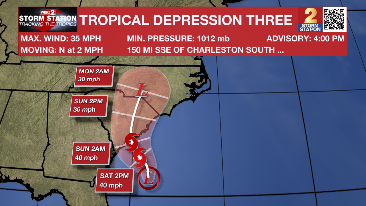
The Tropics: The National Hurricane Center began issuing advisories and forecasts for Tropical Depression Three on Friday afternoon. If the system can gain enough strength and organization to be classified as a tropical storm, it would take the name Chantal.
Trending News
Satellite wind data indicated that the system located about 150 miles off the northeast Florida coast has become better defined Friday with an area of strong winds located on its east side. Showers and thunderstorms are also persisting near and to the east of the center. A short-lived tropical depression or storm will drift northward before it moves inland over the southeastern U.S. by early Sunday. Heavy rainfall is possible across portions of west-central and southwestern Florida through early Saturday, and across coastal sections of the Carolinas beginning later on Saturday. This system will not bring any impacts to Louisiana or the immediate Gulf Coast.
Get the latest 7-day forecast and real-time weather updates HERE.
Watch live news HERE.
– Josh
The Storm Station is here for you, on every platform. Your weather updates can be found on News 2, wbrz.com, and the WBRZ WX App on your Apple or Android device. Follow WBRZ Weather on Facebook and X for even more weather updates while you are on the go.
More News
