Sunday AM Forecast: Enjoy the perfect May weather before a stormy week arrives
Enjoy sunny and dry conditions through Monday with low humidity. Storms begin Tuesday, with multiple rounds expected through the end of the week.
Today & Tonight: The weather will be about as good as you can get for early May standards. Sunshine will dominate all day long, with highs near 81 degrees. Humidity will be non-existent, so enjoy these nice conditions! Skies will stay clear in the overnight hours, leading to lows in the middle 50s.
Up Next: Monday will continue the great weather conditions, although highs will be slightly warmer. This will be the last day of this, so make sure to get outside while you can. Moisture will rapidly increase on Tuesday as a warm front moves through the region. This will spark numerous showers and thunderstorms. Round after round is expected after this point, all the way through the end of the week. There is already early indications that severe weather and heavy rainfall will be possible, especially on Tuesday and Wednesday. Many could see rain totals up to 5" by the end of the week, with isolated higher amounts.
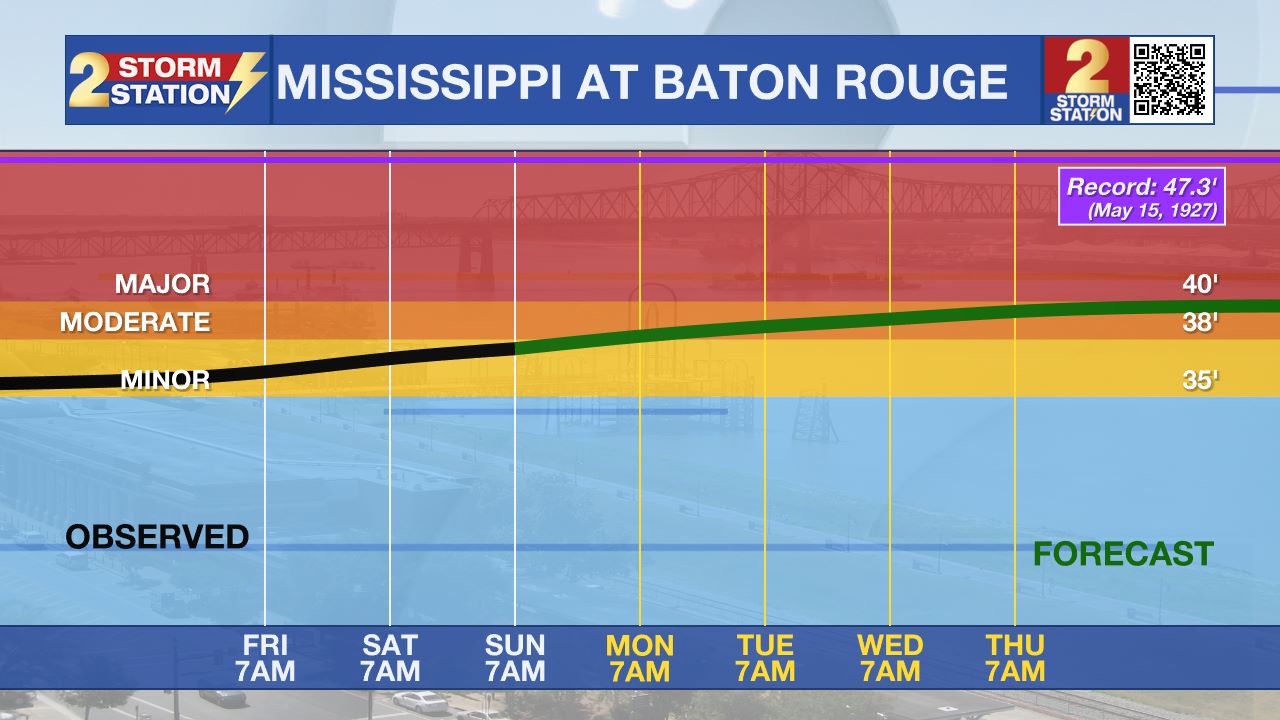
River Flooding: The National Weather Service has issued a RIVER FLOOD WARNING for the Mississippi River at Red River Landing, Baton Rouge, Donaldsonville, and Reserve, as well as the Atchafalaya River at Morgan City.
• At Red River Landing, flood stage is at 48 feet. The river has crested at around 59.5 feet with levels only slightly lower at the moment. This is in moderate flood stage. At this level, the east bank levee will be topped, and the prison farmland between the two levees will be inundated. Angola Landing will be under water, closing the ferry there. All river islands along the reach from Red River Landing to Baton Rouge will remain inundated with recreational camps and river bottom farmland under water. This gauge will fall below flood stage around May 14.
Trending News
• At Baton Rouge, flood stage is 35 feet. The river has crested at around 42.3 feet with levels holding steady for now. This is in major flood stage. Around these levels, the grounds of the older part of Louisiana State University's campus become soggy. This includes the area around the Veterinary Medicine building, the Veterinary Medicine Annex, and Alex Box Stadium. Levees protect the city of Baton Rouge and the main LSU campus at this level. Caution is urged when walking near riverbanks. This gauge will fall below flood stage around May 12.

• At Donaldsonville, the flood stage is at 27 feet. The river has crested at around 30.8 feet with levels holding steady for now. This is in moderate flood stage. Around these levels, navigation becomes difficult for smaller river craft. Safety precautions for river traffic are urged. After cresting, the river will fall below flood stage around May 10.
• At Reserve, flood stage is at 22 feet. The river has crested at around 23.7 feet with levels holding steady for now. This is just shy of moderate flood stage. Around these levels, slow-bell procedures will be enacted for river transportation. After cresting, the river will fall below flood stage around May 9.
• At Morgan City, flood stage is at 6 feet. The river has crested at around 6.6 feet with levels holding steady for now. This is in minor flood stage. At 6 feet, the city dock will be under water. Water will cover the lower end of Belleview Front Street in Berwick. Vessel traffic will be affected by stronger river currents. Vessel traffic safety rules will be strictly enforced by the U.S. Coast Guard. The river will fall below flood stage around May 9.
Get the latest 7-day forecast and real-time weather updates HERE.
Watch live news HERE.
- Balin
The Storm Station is here for you, on every platform. Your weather updates can be found on News 2, wbrz.com, and the WBRZ WX App on your Apple or Android device. Follow WBRZ Weather on Facebook and X for even more weather updates while you are on the go.


