

Latest Weather Blog
Thursday PM Forecast: weak front brings subtle change ahead of weekend
A beautiful stretch of spring weather continues across the Baton Rouge area, with sunshine dominating the forecast and just a slim chance of rain in sight. Adding to the pleasant conditions, there is no noticeable humidity in sight.
Tonight & Tomorrow: Overnight, a weak front will slide through the region, but don't expect much more than a few high clouds and maybe a slight breeze. Temperatures will drop into the upper 50s. By Friday, cooler and drier air settles in behind the front, bringing dew points down into the 40s and highs in the mid-to-upper 70s — perfect weather for getting outdoors.
Weekend & Beyond: The weekend continues this cool and dry trend, with sunny skies, highs in the mid-70s, and crisp morning lows in the upper 40s — about 10 degrees below normal for April. Saturday and Sunday look absolutely gorgeous.
Heading into next week, high pressure sticks around and gradually warms us up. Monday and Tuesday bring a return to low 80s for highs, with slightly milder mornings in the upper 50s and low 60s. A weak front is expected to pass through Tuesday night, but with limited moisture, the best we can expect is a brief spotty shower — only about a 10% chance, and most will stay dry. Wednesday looks sunny again, with highs in the low 80s and morning lows dipping back into the 50s. All in all, it’s a calm, comfortable, and mostly dry spring forecast — ideal for enjoying some fresh air without sweating it out or getting rained on.
River Flooding: The National Weather Service has issued a RIVER FLOOD WARNING for the Mississippi River at Red River Landing until May 5. Flood stage is 48 feet. Moderate flooding is expected with a crest near 57 feet on April 22. At these levels, Angola farmland on the left bank becomes inundated. Caution is urged when walking near riverbanks.
Trending News
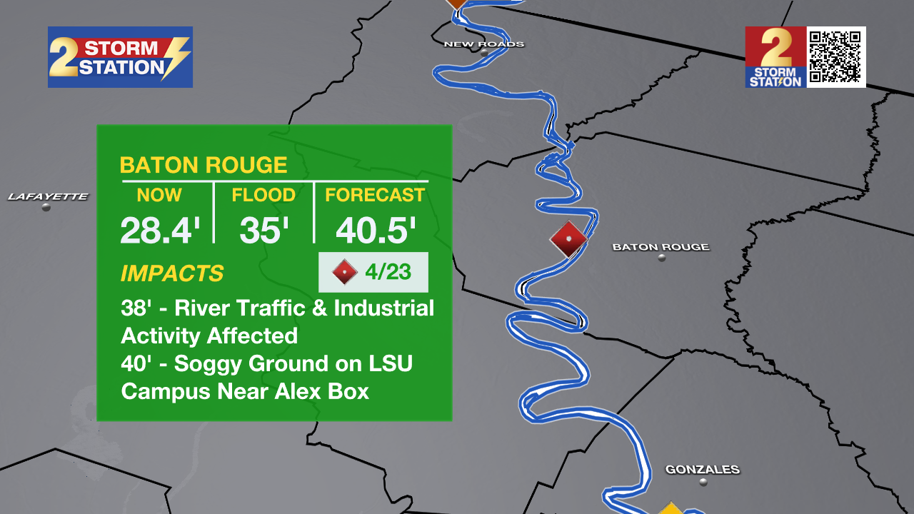
In addition, the Mississippi River gauge at Baton Rouge is projected to reach minor flood stage on Monday. Flood stage is at 35 feet. Major flood stage is expected on April 23 with a crest near 40 feet. Although "major flooding" sounds daunting, the city of Baton Rouge will see no impacts due to levee protection. However, industrial activity and navigational traffic on the river side of the levee will see impacts.
The National Weather Service has also issued a RIVER FLOOD WATCH for the Atchafalaya River at Simmesport, Butte La Rose, and Morgan City until further notice.
• At Simmesport, flood stage of 40 feet may be reached by April 24. There will be flooding of areas inside the levees of the Atchafalaya Floodway and considerable flooding in the backwater storage area in Avoyelles Parish.
• At Butte La Rose, flood stage of 20 feet may be reached by April 25. Minor flooding of the nearby areas could occur.
• At Morgan City, flood stage of 6 feet may be reached by Wednesday morning. At 7 feet, buildings at the foot of Ann Street on the river side of the flood wall will flood as water overtops the Rio Oil Company dock. Buildings on the river side of the Berwick floodwall will flood. River traffic restrictions will be strictly enforced. In addition, backwater flooding could potentially impact portions of areas around Lake Palourde and Stephensville.
Get the latest 7-day forecast and real-time weather updates HERE.
Watch live news HERE.
– Josh
The Storm Station is here for you, on every platform. Your weather updates can be found on News 2, wbrz.com, and the WBRZ WX App on your Apple or Android device. Follow WBRZ Weather on Facebook and X for even more weather updates while you are on the go.
More News
