

Latest Weather Blog
Wednesday AM Forecast: More afternoon storms before first taste of Summer this weekend
Watch out for more active weather this afternoon! By the weekend, we trade rain gear for sunglasses and flip-flops as dry and steamy conditions take over.
Here is a breakdown of what to expect
• Wednesday: afternoon showers and thunderstorms
• Thursday & Friday: trending drier – less rain, heating up
• The Weekend: very warm and humid, mainly dry & sunny
Trending News
Today & Tonight: Some patchy fog may form near sunrise on Wednesday, giving way to a mix of sun and clouds as the day goes on. An upper-level disturbance moving in from Texas will bring another round of showers and thunderstorms to the Capital Area this afternoon. About 70% of the region is expected to receive measurable rainfall, with the potential for heavy downpours and gusty winds. The most active period is expected around the afternoon commute, so be sure to drive carefully and watch for water on roads, especially in areas with poor drainage.
Tonight, mainly cloudy skies will hold overnight lows to the upper-60s around southeast Louisiana.
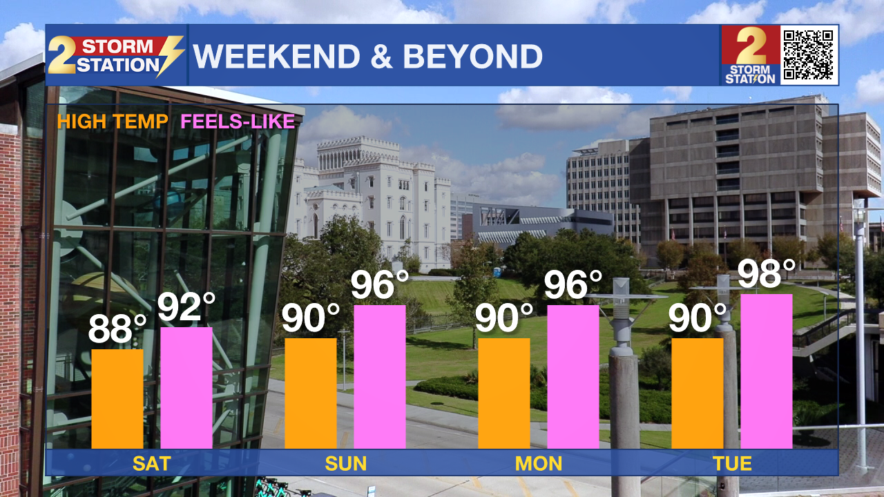
Up Next: As an upper-level ridge builds over the southeastern U.S. heading into the weekend, rain chances will steadily decrease. A few isolated showers and thunderstorms are possible Thursday afternoon, but activity will taper off by Friday. By the weekend, rain is unlikely. With drier conditions and increasing sunshine, temperatures will begin to climb. Highs will reach the upper 80s on Friday and Saturday, with Sunday through Tuesday expected to top out around 90 degrees. Unfortunately, rising humidity will add to the heat, pushing "feels like" temperatures into the mid-90s for the first time this year. Be sure to stay hydrated as your body adjusts to the warmer, steamier conditions.
River Flooding: The National Weather Service has issued a RIVER FLOOD WARNING for the Mississippi River at Red River Landing, Baton Rouge, Donaldsonville, and Reserve, as well as the Atchafalaya River at Morgan City until further notice.

• At Red River Landing, flood stage is at 48 feet. Moderate flooding is already occurring. A crest of 59 feet is expected around April 30. At this level, Angola prison farmland between the two levees will be inundated and the east bank levee will be topped. Angola Landing will be underwater, closing the ferry. All river islands along the reach from Red River Landing to Baton Rouge will remain inundated with recreational camps and river bottom farmland under water. This gauge will fall below flood stage around May 13.
• At Baton Rouge, flood stage is 35 feet. Moderate flooding is already occurring. Major flood stage will be reached on Thursday, cresting at 41.0 feet on May 1. Around these levels, the grounds of the older part of Louisiana State University's campus become soggy. This includes the area around the Veterinary Medicine building, the Veterinary Medicine Annex, and Alex Box Stadium. Levees protect the city of Baton Rouge and the main LSU campus at this level. Caution is urged when walking near riverbanks. This gauge will fall below flood stage around May 11.
• At Donaldsonville, the flood stage is at 27 feet. Minor flooding is already occurring. A crest of 30 feet is expected around May 1—right at moderate flood stage. Around these levels, navigation becomes difficult for smaller river craft. Safety precautions for river traffic are urged. After cresting, the river will fall below flood stage around May 10.
• At Reserve, flood stage is at 22 feet. Minor flooding is forecast to begin Thursday. A crest of 23.5 feet is expected around May 1. Around these levels, slow-bell procedures will be enacted for river transportation. After cresting, the river will fall below flood stage around May 9.
• At Morgan City, flood stage of 6 feet may be reached on Saturday. Moderate flooding with a crest of 7 feet is forecast on Friday, May 2. At 7 feet, buildings at the foot of Ann Street on the riverside of the flood wall will flood as water overtops the Rio Oil Company dock. Buildings on the riverside of the Berwick floodwall will flood. River traffic restrictions will be strictly enforced. In addition, backwater flooding could potentially impact portions of areas around Lake Palourde and Stephensville.
Get the latest 7-day forecast and real-time weather updates HERE.
Watch live news HERE.
- Emma Kate C.
The Storm Station is here for you, on every platform. Your weather updates can be found on News 2, wbrz.com, and the WBRZ WX App on your Apple or Android device. Follow WBRZ Weather on Facebook and X for even more weather updates while you are on the go.
More News
