

Latest Weather Blog
Wednesday PM Forecast: Spring in full bloom, gorgeous weather for weekend plans
The beautiful stretch of spring weather is set to continue. Sunglasses and sunscreen will be important items to have through the weekend.
Tonight & Tomorrow: A slight warming trend is underway. Even so, another cool night is expected with lows dropping into the low-50s – a contrast from recent lows in the 40s. April sunshine and a warmer starting point will move highs into the low-80s on Thursday. It will be a picture-perfect day, especially with low humidity and wind.
Up Next: A weak cool front Thursday night will bring a few passing clouds and perhaps a stray sprinkle while most are sleeping. The odds of any one point location experiencing rain from this are so low that it’s hardly worth mentioning. The warming trend will be halted by the frontal passage, but not by much. Sunshine returns quickly behind the front, with highs in the mid to upper-70s on Friday.
Weekend & Beyond: The weekend weather looks absolutely gorgeous for a busy festival-filled weekend. Sunshine will dominate, so do make sure to wear sunscreen. April sunshine is just as intense as the August sun. Cool mornings in the 40s and low-50s will transition to mild afternoons. Highs will warm into the mid-70s on Saturday before touching 80° on Sunday. Expect the mercury to continue to climb next week, and some will notice a touch of humidity. Even next week, rain chances appear slim.
River Flooding: The National Weather Service has issued a RIVER FLOOD WARNING for the Mississippi River at Red River Landing from Thursday evening until May 4. Minor flooding is forecast to begin on Thursday night. Flood stage is at 48 feet. Moderate flooding is expected with a crest near 57 feet early on April 23. Around these levels, Angola farmland on the left bank begins taking on water. Caution is urged when walking near riverbanks.
Trending News
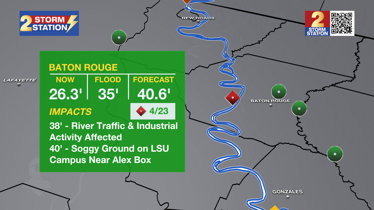
In addition, the Mississippi River gauge at Baton Rouge is projected to reach minor flood stage on Monday. Flood stage is at 35 feet. Major flood stage is expected early on April 23 with a crest near 40 feet. Although "major flooding" sounds daunting, the city of Baton Rouge will see no impacts due to levee protection. However, industrial activity and navigational traffic on the river side of the levee will see impacts.
The National Weather Service has also issued a RIVER FLOOD WATCH for the Atchafalaya River at Simmesport, Butte La Rose, and Morgan City until further notice:
• At Simmesport, flood stage of 40 feet may be reached by April 24. There will be flooding of areas inside the levees of the Atchafalaya Floodway and considerable flooding in the backwater storage area in Avoyelles Parish.
• At Butte La Rose, flood stage of 20 feet may be reached by April 25. Minor flooding of the nearby areas could occur.
• At Morgan City, flood stage of 6 feet may be reached by April 16. Moderate flooding at 7 feet is forecast by April 18. At 7 feet, buildings at the foot of Ann Street on the river side of the flood wall will flood as water overtops the Rio Oil Company dock. Buildings on the river side of the Berwick floodwall will flood. River traffic restrictions will be strictly enforced. In addition, backwater flooding could potentially impact portions of areas around Lake Palourde and Stephensville.
Get the latest 7-day forecast and real-time weather updates HERE.
Watch live news HERE.
-- Meteorologist Malcolm Byron
The Storm Station is here for you, on every platform. Your weather updates can be found on News 2, wbrz.com, and the WBRZ WX App on your Apple or Android device. Follow WBRZ Weather on Facebook and X for even more weather updates while you are on the go.
More News
