

Latest Weather Blog
Tuesday Midday Video Forecast
Related Story
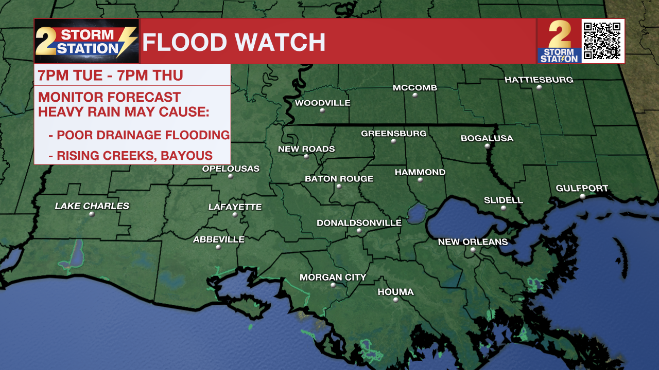

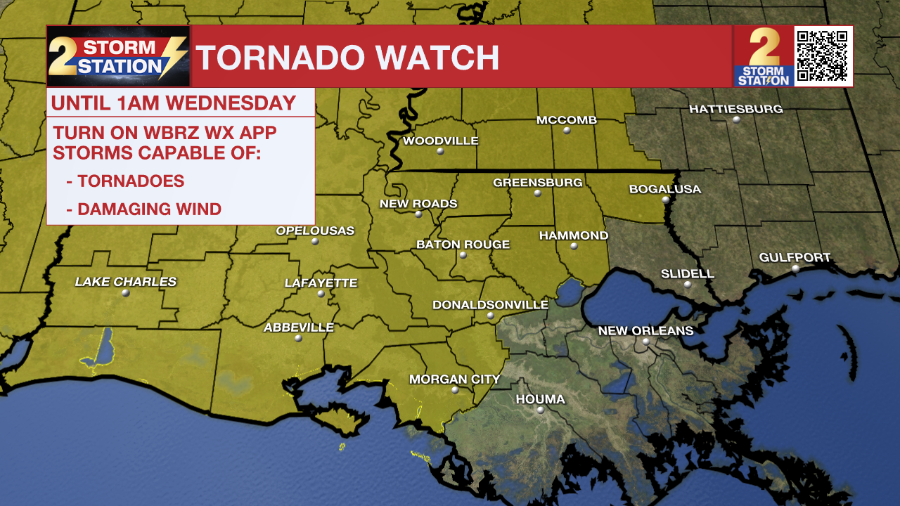
Tonight: Rain coverage and intensity will increase after sunset as an organized complex of thunderstorms moves into the I-10/12 corridor. The threat of severe weather is not off the table, as some thunderstorms could cause gusty winds, large hail, and possibly a brief spin-up tornado. However, heavy rain is the primary concern for much of the night. Rain rates will be intense at times, and thunderstorms could repeat over the same locations. Several inches could fall in a few locations. As a result, flash flooding is possible, with areas affected experiencing poor drainage flooding and rapid rises on smaller creeks and streams. Allow extra time for the morning commute in case of road closures, and be cautious of any flooded roads. Do not attempt to drive through floodwater. Temperatures will bottom in the upper 60s.
Wednesday: The showers and thunderstorms are expected to linger into early Wednesday but may well use up most of the energy in the atmosphere, allowing for a break in the action by afternoon. Mainly cloudy skies will remain as temperatures hover in the upper 70s. Don’t get too comfortable in any dry time—more rain will be on the way. There is some uncertainty as to when the next round of showers and thunderstorms will develop. A weak impulse in the atmosphere could reasonably set off some more activity during the evening or overnight, but it is also plausible that there is not enough energy for storms until the atmosphere recharges and a stronger impulse arrives.
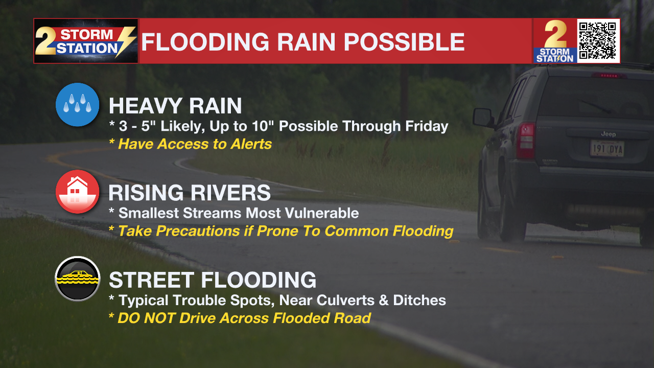
Up Next: Another round of showers and thunderstorms will spark in response to an impulse in the atmosphere pushing a front south across the region late Thursday into Friday. At that point, any extra rain would aggravate the flash flood risk due to previously saturated soils. Friday brings lower coverage in showers and thunderstorms, but still 40% of the 13 Parish, 2 County Area is pegged for measurable rain. New to the forecast, isolated showers and thunderstorms have been added for Saturday and Sunday as well, thanks to some lingering energy into the weekend. Though the flood threat should be lower, some hail may occur in any storms. By early next week, expect some drier times with more sunshine, lower humidity, and comfortable temperatures.
River Flooding: The National Weather Service has issued a RIVER FLOOD WARNING for the Mississippi River at Red River Landing, Baton Rouge, and Donaldsonville, the Atchafalaya River at Morgan City, and the Tangipahoa River at Robert. For the latest levels and forecasts, CLICK HERE.
The Storm Station is here for you, on every platform. Your weather updates can be found on News 2, wbrz.com, and the WBRZ WX App on your Apple or Android device. Follow WBRZ Weather on Facebook and X for even more weather updates while you are on the go.
News
