

Latest Weather Blog
7 tornadoes confirmed after severe thunderstorms on Wednesday
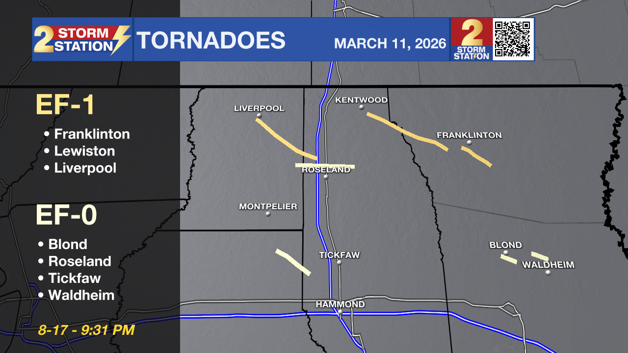
The National Weather Service (NWS) has released its preliminary damage survey results following the line of severe thunderstorms that raced through the region on Wednesday night (March 11). Crews confirmed that at least seven tornadoes touched down across five Louisiana parishes, leaving a trail of snapped trees and minor structural damage.
The strongest of the confirmed twisters struck the Franklinton area, where winds reached 105 mph. Fortunately, despite the widespread nature of the storms, no fatalities or injuries were reported.
Detailed Tornado Reports
Trending News
Franklinton (Washington Parish)
The most intense tornado of the night, this EF1 tracked through southern Franklinton, damaging a floral shop and a business sign. It reached its peak intensity south of LA 1072, where it snapped nearly 50 pine trees.
Rating: EF1
Peak Wind: 105 mph
Path Length: 5.14 miles
Time: 9:03 PM – 9:13 PM
Liverpool (St. Helena & Tangipahoa Parishes)
Developing near LA 1043, this tornado moved southeast toward I-55. It was responsible for uprooting and snapping numerous trees along its 11-mile path before dissipating near Roseland.
Rating: EF1
Peak Wind: 95 mph
Path Length: 11.66 miles
Time: 8:17 PM – 8:33 PM
Lewiston & Spring Creek (Tangipahoa & Washington Parishes)
This EF1 developed along LA 38 and traveled over 13 miles. It notably snapped a power pole along LA 10 before ending its track near Richardson.
Rating: EF1
Peak Wind: 95 mph
Path Length: 13.48 miles
Time: 8:38 PM – 9:00 PM
Roseland (St. Helena & Tangipahoa Parishes)
A quick-forming EF0 tornado developed north of Kedron and tracked eastward across I-55, causing minor tree damage and snapping large limbs.
Rating: EF0
Peak Wind: 85 mph
Path Length: 8.73 mile
Time: 8:29 PM – 8:42 PM
Blond (St. Tammany Parish)
Moving through the Blond community, this tornado tracked from Allison Road across Hwy 40, eventually dissipating near Lee Road Junior High School.
Rating: EF0
Peak Wind: 80 mph
Path Length: 2.26 miles
Time: 9:21 PM – 9:24 PM
Waldheim (St. Tammany Parish)
Forming almost immediately after the Blond tornado dissipated, this weak twister caused minor tree damage near Elderberry Lane and Oalmann Road.
Rating: EF0
Peak Wind: 75 mph
Path Length: 2.37 miles
Time: 9:28 PM – 9:31 PM
Tickfaw (Livingston & Tangipahoa Parishes)
Touching down north of Albany, this tornado was confirmed via radar signatures and tree debris. Surveyors noted a downed tree on I-55 and may extend this track as more data arrives.
Rating: EF0
Peak Wind: 65 mph
Path Length: 5.79 miles
Time: 8:32 PM – 8:38 PM

In Hammond, survey teams found scattered light wind damage east of downtown, including two uprooted trees. However, they determined the damage was likely caused by straight-line winds rather than a tornado, noting that a tornado in such an urban area would have caused more widespread destruction.
These findings are preliminary. NWS Meteorologists will continue to analyze satellite data over the coming days, which may lead to adjustments in path lengths or the addition of new tornado tracks.
The Storm Station is here for you, on every platform. Your weather updates can be found on News 2, wbrz.com, and the WBRZ WX App on your Apple or Android device. Follow WBRZ Weather on Facebook and X for even more weather updates while you are on the go.
More News
