Monday PM Forecast: low humidity holds just a few more days
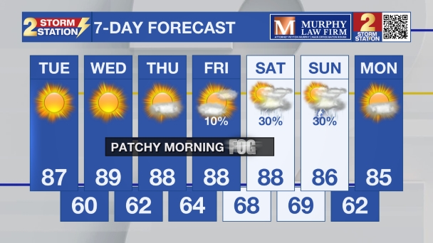
Seasonably cool mornings and comfortably warm afternoons will remain the theme through midweek. A bit of humidity will push in before the weekend and the next chances for rain.
Tonight & Tomorrow: Especially away from the immediate city and lakes, another clear and cool night is expected. Lows will likely dip into the upper 50s in the Baton Rouge Area, and will reach the mid-50s in some of the more rural, low-lying areas north and east of the city. A light jacket may come in handy a few hours either side of dawn. Plenty of blue sky and sunshine will be found again on Tuesday. Highs will warm a few degrees compared to previous afternoons, surging into the upper 80s.
Up Next: Afternoon highs will steadily climb through midweek, reaching close to 90 degrees by Wednesday. For October, that’s about 5 to 7 degrees above our average. The good news is that while the afternoons are warm, the dry air will keep things comfortable enough for outdoor activities, though you’ll want to stay hydrated—that dry air can pull moisture out of you pretty quickly.

The biggest shift will come toward the end of the week, and that will be a change in how the air feels. Our winds will start to shift from the north to the east and eventually the southeast. This southerly flow will slowly but surely drag up the moisture levels. In turn, enough moisture will be available for some patchy fog development on several mornings, especially Wednesday through Saturday.
Trending News
By the time we hit the weekend, you’ll notice the air is feeling heavier. With that, our next rain chances start to enter the forecast as the next cold front approaches. Confidence in the timing of the front is low right now, and so a mention for showers and thunderstorms is in the forecast for both days as the front could bring action as soon as Saturday afternoon or as late as Sunday morning.

The Tropics: Tropical Storm Lorenzo has strengthened slightly over the central tropical Atlantic, with maximum sustained winds of 50 mph. As of Monday, the storm was located about 1,150 miles west of the Cabo Verde Islands and was moving to the northwest at 16 mph. Expect this movement to gradually slow down before the storm turns north on Tuesday. While little change in strength is anticipated through early Tuesday, gradual intensification is possible by the middle of the week.
Get the latest 7-day forecast and real-time weather updates HERE.
Watch live news HERE.
– Josh
The Storm Station is here for you, on every platform. Your weather updates can be found on News 2, wbrz.com, and the WBRZ WX App on your Apple or Android device. Follow WBRZ Weather on Facebook and X for even more weather updates while you are on the go.


