

Latest Weather Blog
Saturday PM Forecast: Severe weather threat, followed by lowest temps of the fall
A cold front moving through overnight will bring a line of showers and storms, some of which could be severe. After the front passes, cooler and drier air will lead to the lowest temperatures of the fall season so far.
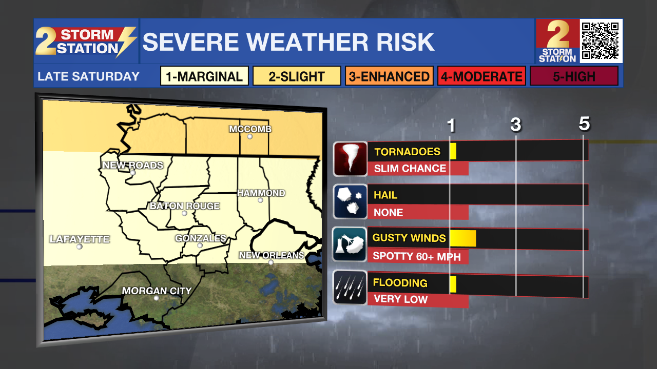
Tonight & Tomorrow: A lot of changing weather conditions are expected over the next 24-36 hours. We will start off with a cold front rolling through overnight. A broken line of showers and storms are expected after midnight. Ingredients will be at least marginally conductive for a low-end severe weather threat. The Storm Prediction Center has placed most of the area under a level 1/5 risk, with a 2/5 risk in southern Mississippi. Gusty winds, and a brief tornado will be the main threats. Have a way to receive alerts in case a warning is issued. Most of the shower activity will be gone by daybreak. Cooler and drier air will steadily filter in, leading to highs only topping out in the upper 70s. Skies will be completely sunny.
Up Next: The lowest temperatures of the fall season so far are expected Monday morning. Lows will bottom out near 51 degrees, with some locations in the upper 40s. The daytime hours will feature sunny skies, no humidity, and highs in the lower 80s. Another reinforcing front will arrive on Tuesday. This will briefly raise temperatures before they drop again after the front passes.
The Tropics: A tropical wave located several hundred miles east of the Windward Islands continues to produce a broad area of showers and thunderstorms. Earlier satellite wind data indicated the system lacks a closed circulation, but is producing winds of 30 to 35 mph to the north of the wave axis. Environmental conditions appear marginally conductive for slow development over the next couple of days as the system moves quickly westward at 20 to 25 mph, crossing the Windward Islands and entering the Caribbean Sea by early next
week. By the middle of next week, the system is expected to slow down over the central Caribbean Sea, where environmental conditions could become more favorable for further development.
Trending News
A non-tropical area of low pressure is located several hundred miles northeast of Bermuda. There is a slight chance that the system could develop some subtropical characteristics over the next day or so before it turns northeastward into cooler ocean waters on Sunday.
Get the latest 7-day forecast and real-time weather updates HERE.
Watch live news HERE.
— Balin
The Storm Station is here for you, on every platform. Your weather updates can be found on News 2, wbrz.com, and the WBRZ WX App on your Apple or Android device. Follow WBRZ Weather on Facebook and X for even more weather updates while you are on the go.
More News
