

Latest Weather Blog
Sunday PM Forecast: Full-on summer mode with heat, steam, and a few storms
Louisiana summer is here. The classic heat, humidity, and afternoon pop-up storms aren't going anywhere anytime soon.
Tonight & Tomorrow: With afternoon storms gradually fizzling out through the evening, skies will quickly turn mostly clear. Expect be a muggy and mild night, again, with an overnight low in the mid 70s. An upper-level ridge will still play a dominant role on Monday by maintaining the steamy feel and suppressing overall storm activity. But the ridge will not be exactly centered on the area. This will open the door for a weak disturbance(s) to ride along its edge and brush up against the Gulf Coast. This could stir up a few more showers and storms as things heat up. However, such storms would still be spotty in coverage. Monday will be far from a washout. Outside of rain, afternoon temperatures will sit in the low to mid 90s with feels-like temperatures in the triple digits.
Up Next: Tuesday will bring more of the same hot and humid conditions. Spotty to isolated storms will be possible as weak disturbances continue to make glancing passes with the area. But by midweek, an intrusion of dry air aloft will keep rain chances to a minimum. Then, the focus shifts almost entirely to the heat. With plenty of humidity and highs in the mid 90s, there might be a need for Heat Advisories again. Moving into the weekend, improving moisture levels will help support a greater number of afternoon storms. But rain aside, the steam machine will still be turned up to the max.
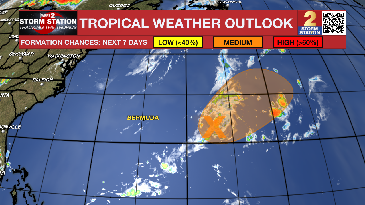
The Tropics:
Roughly 450 miles east of Bermuda, a cluster of showers and thunderstorms are showing some signs of organization. Earlier satellite wind data indicated a well-defined circulation. Additional organization of the activity could lead to a short-lived tropical depression over the next day or so. By Tuesday, this system will encounter cooler waters and into a region of strong upper-level winds, ending its opportunity for further development. This system will continue moving over open water and not be a concern for land regardless of development.
Trending News
Get the latest 7-day forecast and real-time weather updates HERE.
Watch live news HERE.
-- Meteorologist Malcolm Byron
The Storm Station is here for you, on every platform. Your weather updates can be found on News 2, wbrz.com, and the WBRZ WX App on your Apple or Android device. Follow WBRZ Weather on Facebook and X for even more weather updates while you are on the go.
More News
