

Latest Weather Blog
Tuesday AM Forecast: Cold front will have most reaching for jackets by Wednesday morning
A slow moving cold front will stall over the Capital Area today, bringing cooler air to the region over the next 24 hours. By Wednesday morning, most neighborhoods will be in the low-50s and many will be reaching for jackets.
Today & Tonight: Tuesday's forecast remains a bit tricky due to the location of a cold front hanging over the region during the day. Morning temperatures from Ascension Parish and north will be comfortable in the low to mi-60's and areas south will be a bit muggier, only falling near 70 degrees. The cold front creating the temperature gradient will shift north slightly throughout the day, again resulting in cooler temperatures for those north of the front and warmer, muggier conditions south of the boundary. In Baton Rouge, highs in the upper-80s will be accompanied by a touch of humidity this afternoon. Skies will start off cloudy and become mostly sunny by sunset.
Finally, the cold front will pass through the entire area late Tuesday, bringing cooler air to all parishes. Wednesday morning, the Capital City will see a low near 54 degrees and neighborhoods close to the LA/MS state line may even dip into the 40s!
For those hoping to catch a glimpse of a comet in the early evening sky again Tuesday, there may be a few clouds blocking the way but overall expect mostly clear conditions.
Up Next: After a chilly start Wednesday, breezy winds out of the north will continue to usher in a cool airmass that will stick around for a couple of days. Wednesday afternoon high temperatures will only warm into the low and mid-70s around the state under full sunshine. Then Thursday morning will see the coolest temperatures in months as lows start off in middle 40's in Baton Rouge. Even cooler temperatures are possible outside of the city. This below-average October chill won't last forever; temperatures will gradually climb into the weekend. But even then, it looks comfortable with little to no rain in sight.
Get the latest 7-day forecast and real time weather updates HERE.
Trending News
Watch live news HERE.
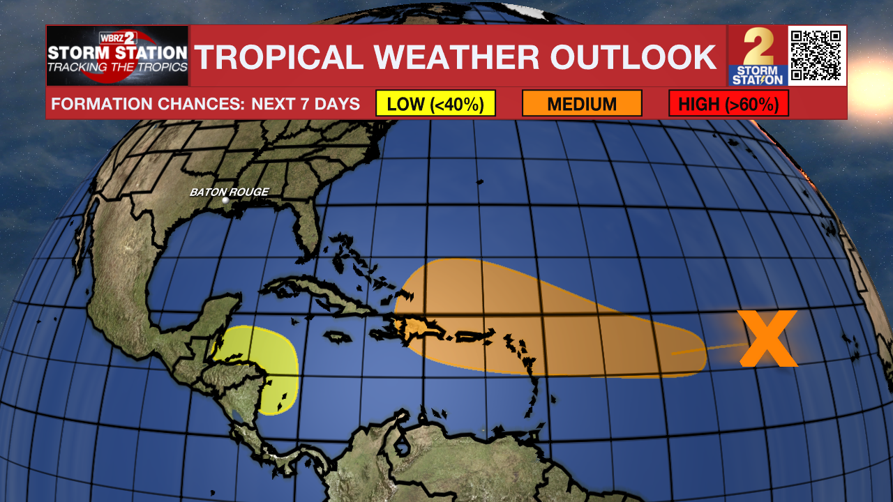
The Tropics: A well-defined area of low pressure located over the central tropical Atlantic is producing occasional showers and thunderstorms. This system remains embedded in a dry air environment, and development is unlikely over the next couple of days. However, this system is forecast to move generally westward and environmental conditions are expected to become more favorable for gradual development by the middle to latter part of this week. A tropical depression could form as the system begins moving west-northwestward and approaches or moves near the Leeward Islands late this week.
A broad area of low pressure could develop over the southwestern Caribbean Sea by the middle to latter portions of this week. Some gradual development is possible thereafter if the system stays over water while it moves slowly west-northwestward towards northern Central America. Regardless of development, locally heavy rainfall is possible across portions of Central America later this week.
- Emma Kate C.
The Storm Station is here for you, on every platform. Your weather updates can be found on News 2, wbrz.com, and the WBRZ WX App on your Apple or Android device. Follow WBRZ Weather on Facebook and Twitter for even more weather updates while you are on the go.
More News
